

A plan in the making
The name of this blog might need to change to reflect the riding I have done this winter. I have ventured too far south. It started by visiting Spicer Ranch just outside of Beatty, NV and learning about the plans of rancher/conservationist/trail builder, David Spicer. My plan was to camp at the Spicer Ranch trailhead, complete with climate controlled rest rooms/showers as well as other amenities, and ride the miles of singletrack on and adjacent to the property. While I was given a personal tour of the Oasis Valley singletrack I learned about “conservation through recreation” which can not only revitalize critical habitat but can simultaneously revitalize the economies of rural Nevada towns like Beatty, NV (politicians and land managers take note). Spicer inspired me to explore the historic railroad beds that linked key mining districts in the area. He further enticed me by noting the rails went into Death Valley NP and pointed out mountain ranges with mixed pinon/spruce forests. So the plan was born, I would follow and evaluate the railroad beds from Tonapah to Beatty, with the goal of establishing a quality north-south Nevada bikepacking route. As a loose plan came together I knew I better act on it.

An ominous start
The next week I was up in the middle of the night, packed and driving out of Reno with 3 inches of snow on my car. Most of our snow storms come in from the west and rarely penetrate deeply into the state. Or the “atmospheric rivers” paint a slash of precipitation across the state from SW to NE. With this in mind I hoped for better weather as I headed SE. The weather along Alt 95 and 95 was milder but not snow-free. I parked off Knapp Ave and pedaled into the snow. I connected with Paymaster Cyn Rd, passed the railroad bed, then made my way to Powerline Rd. With hindsight I would stay on Paymaster Cyn Rd, loop around the General Thomas Hills, then continue to Alkali.


Touring in the land of burros and Joshua Trees
Out of Alkali I followed a powerline service road along the Montezuma Mtns into Goldfield. As I was on a solo trip my companions were the mountain ranges, Joshua Trees, wild burros, and pronghorn antelope. I learned one trick from the burros, use the arroyos to escape the wind. Luckily for now the wind was either a tailwind or crosswind.


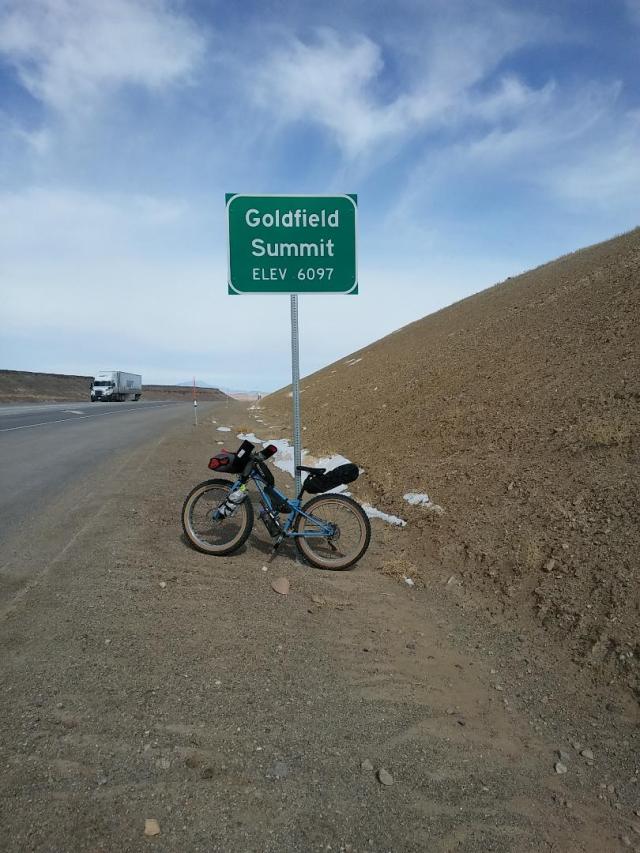
Goldfield, on the rail
As I entered Goldfield I was greeted by a park with a designated bike trail that passed several historic points of interest. Bicycle riding, velo-tourism is on the map in rural Nevada. Now it is a matter of promoting it, getting it connected to other historic areas, and tracking visitors by bicycle. My overall impression of Goldfield was this was an area ripe for exploration by bike. I wonder what could be a multi-day itinerary centered in Goldfield. This will be a future project for sure.


I made my way through Goldfield on the highway. I was thankful for the slow speed limit. I was intrigued by the tourist attractions on the main street but I was focused on making my way south through the main mining district on the east side of town. I turned off on the Tonapah-Tidewater railroad grade at the end of E Ramsey Ave. It was a fantastic ride through the Chispa Hills to Stonewall Flat. The quality of riding on the old grade was fantastic. Occasionally it was broken by washes through the hills but there was always an adjacent route. I was making great time with the strong tailwind and gentle down grade. I was getting concerned on how the return trip might go. I decided to try reversing my direction. I went from 17 mph to less than 5 mph. There is no telling how long the wind will last, how it might change in intensity or direction. I may be rethinking this tour.


Riding in view of Stonewall Mountain, 7945′, past Stonewall Flat to Lida Valley was breath taking. All around me I could see dust storms, snow showers, and bright sunlight. Riding on the elevated grade at one point I passed over an intact wooden culvert. Two big healthy looking coyotes shot out. Beautiful animals. Between riding the railroad grades and adjacent desert roads this is a worthwhile route. There was an abundance of other roads to explore as well.

From Stonewall Flat my original route had me zig-zagging across Lida Valley and into the Gold Hills. I deviated from my original route and crossed Lida Valley to the east toward the highway. I came across a rancher’s well that appeared to be a reliable source of water. The highway is completely fenced off from the adjacent land to keep livestock and wildlife out of traffic. This also makes it challenging for the bike tourist. I crossed a cattle guard on this established road and continued south on the service road (buried fiber optic cable) adjacent to the highway. I came across a gated road to the east, so I took it. My hope was to find a rock outcropping or some shelter from the wind to make camp.


I knew I was getting close to Nellis Air Force Range but there were no signs that I was entering a sensitive area. I was pleased to see a group of pronghorns who kept a safe distance but repeatedly zig-zagged the road ahead of me. Such a beautiful sight. I was intrigued by the road but I knew I needed to make camp, the sun was low, and the temperatures were getting lower. With hindsight I know the railroad bed is just ahead crossing the road and the road continues to the edge of the Air Force Range.


I found a rock outcropping but the wind seemed to make its way around. There was a burro and a few pronghorn just outside of camp. The burro serenaded me in the night. It is good to make friends with your neighbors. There is such relief to get into the tent and be out of the wind. The temperatures were bitter cold on any exposed skin but I had a comfortable night.
Day two: decision making, return to Goldfield and Tonapah


The next morning I had an internal debate on what to do. Option one; make a bee-line to Spicer Ranch along 95 and turn-around or, option two; cut the tour short and make a bee-line for Goldfield and Tonapah, with the idea that it might take two days to get back to the car. The weather was unsettled so I chose the latter. I followed the service road along the highway keeping my eyes peeled for alternate roads. The fence line was a formidable barrier. I descended into Goldfield and stopped off at the Dinky Diner for a great bacon, egg, and biscuit breakfast. I fueled up, replenished my water, and headed out to the railroad grades between Alkali and Tonapah.


Leaving Goldfield I was intrigued by the mines and dirt roads in the immediate area. The highest concentration of mines is to the east in the Goldfield Hills. To the west is the Montezuma Range, Clayton Ridge, and the Silver Peak Range. The town of Gemfield also seemed to be beckoning/advertising to tourists off the highway. I plan on spending some quality time in this area.


I picked up the railroad grade at the Klondike Site and rode it until it crossed the Paymaster Cyn Road. This was the road I was parked off of but my memory did not include this long return climb. The snow was gone and the day was slightly warmer.

What I rode, what I carried

My Surly Ice Cream Truck was outfilled with the Surly Nate 26×4.0 tires. The bike carried 3L of water, 1.5L under the down tube and 1.5L on the fork. The other fork leg carried a 7L stuff sack with food, cup, spoon, knife, stove and fuel. The tiny frame bag carried a flat repair supplies and a spare pair of gloves. My seat bag contained my first-aide kit and dry/warm clothes. My handlebar bag contained my down quilt, sleeping pad, and tarp tent. Attached to my handle bar bag was my Spot GPS messenger. I had two feed bags on my bars with camera and phone in one and snacks in the other. My top tube bag contained a small towel, spare battery, headlamp, mini-tool, and sunscreen. I don’t have a pack weight. While the bike was heavy to lift it felt fine to ride.
I wore cycling shorts, tights, a long sleeve synthetic base layer, a long sleeve wool base layer, cycling wind vest and the Patagonia Hoodini hooded windbreaker. I wore wool socks, mountain bike shoes, and shoe covers. I brought two pairs of light weight gloves to ride in but I also have BarMitts on my handle bars.
My dry/warm camp clothes included bulky wool socks, silk weight long underwear, nylon pants, synthetic long sleeve base layer, hooded down jacket, hat and gloves. The strategy for the adverse conditions was to set up the tent, get out of the wind, and change clothes. Then under the down quilt for the next 11 hours. The long nights of winter bikepacking can be an endurance in the tent.
I have been asked, what is my sleep system?
In addition to my camp clothes, which I wear to sleep, I start with my emergency blanket as my ground cloth. On top of that is my inflatable sleeping pad. Then I am inside a synthetic sleeping bag liner with my Sierra Designs down quilt on top. When it is very cold I put a cloth over my face. This system keeps me comfortable in temperatures into the teens. I find it is key to warm the extremities first and then everything stays warm.
What was my meal planning?
Breakfast:
-Breakfast bars (too crumbly when frozen)
-Juice pouches (surprisingly satisfying)
-Coffee, cocoa, instant, mixed! (hot and brown, I convinced myself this was good)
Lunch/Bike snacks: (I notoriously don’t eat much on the bike)
-Trail mixes, mixed
-Hammer Gel
Dinner:
-Starts with any leftovers from lunch
-Ham and cheese quesadillas, pre-made wrapped in foil
-Jerky
-Cocoa, instant hot brown, with mini-marshmallows (as important as a hand/belly warmer as a beverage, ditto with morning hot drinks)
My meals were meant to provide about 500 calories per. I kept them small to make sure digestion was easy. This diet definitely would require more calories snacking on the bike.
In review and by the numbers
There is always the important step of review and modify what you carried. My Garuda/ Dana Designs Nuk Tuk tent is too big and heavy for most of my needs. But it is what I have and until I have a replacement I will make due. The advantage to its size is I have plenty of protected living space for spreading out, cooking, and sitting up. This luxury is appreciated when wind and snow compress the otherwise 4-person foot print to a 2-person foot print. I have had this tent on innumerable trips over the last 15+ years so it has truly stood the test of time.
My sleep system is great. The inflatable Insul Mat, Ether-Thermo6: Reg sleeping pad by Pacific Outdoor Equipment does its job. While this company had a popular run in the outdoor industry their products have outlived their company. The valve did freeze at one point but that is not a slight on the pad. I use a Jack Wolfskin Pongee sleeping bag liner to keep myself covered even if my sleeping quilt slips away in the night. I also prefer the feel of the fabric over the fabric used in most sleeping bags. It provides a bit of comfort in addition to moisture management while keeping things clean and washable. My sleeping bag is The Backcountry Quilt by Sierra Designs. This 2-season quilt has 800 fill weight DriDown is rated to 38/28. While mine is a few years old it has been updated for 2018 and has a warmer model rated to 28/17.
My meals were fine. Cooking was kept to a minimum. Flavor was good. I was satisfied. Were the hot drinks worth carrying the stove and fuel? Yes. I will always try new meal items on each trip.
My Surly Ice Cream Truck worked well on this trip. The four inch wide tires carried me through the sandy and rocky sections without a hiccup. The choice in tire width comes down to estimating their efficiency “cost”. What is the difference of a 1-2 mph slower average speed vs pushing your bike through sand for a few hours? Nevada is a wild place to explore. Over a long distance you will encounter all possible terrain.
My route outbound was a great route about 68 miles. My return along the highway was 10 miles shorter and not nearly as interesting. There are numerous opportunities for alternate routes in the area. I would like to explore the length of Paymaster Cyn Rd out of Tonapah as well as E. Railroad Springs Rd south of Goldfield. While the historic railroad grades are usable at times they run close to the highway making them less than ideal. The grades immediately around Tonapah and Goldfield were particularly scenic and recommendable routes.

Sounds like a great adventure in a starkly beautiful area. I found your recommendations on what to bring very useful. I really must invest in some shoe covers for windy/cold conditions!
Thank you, Amanda. The chemical hand/toe warmers can be slipped between your shoes and shoe covers. It is always worth having warm hands and feet but so easy to neglect.