I will head north for ten minutes and if I think I am heading to Winnemucca Ranch Rd then I will continue on to complete the loop. If not I will turn around and finish this ride as an out-and-back. But the aesthetics of a loop are so much better. But you are not really sure of the route ahead of you. People will ask why you didn’t complete the loop. You have 3 hours of riding in your legs, 25 miles, thousands of feet of climbing, and that much ahead of you at least. And probably that many hours of daylight as well. And the aesthetics of a loop won over the low risk option of the out-and-back. This time.

I have made many trips to this area around the Dogskin Mountains, Bedell Flat, Winnemucca Valley, and have always been captivated by State Line Peak to the west. It has a characteristic wedge shape with its abrupt face in view from the east. State Line Peak is in the Fort Sage Range which lies in California and Nevada. I once plotted a route with a round trip from Moon Rocks, figured it would be a big day, but never thought I would do it in winter on packed snow. Billy Vicks and I made a trip around the Dogskins from Moon Rocks that followed Dry Valley Creek to Upper Dry Valley but today’s ride is what I had in mind while we did this.

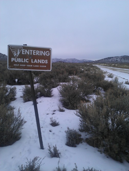
This trip began off the public land access in Antelope Valley. Just a short drive north of Reno I have used this spot as jumping off point for previous backroad adventures. The north valleys can be snow prone due to lake affect snow storms coming from Pyramid Lake. There were several inches of snow in the chaparral and the road surface was packed snow that had not yet gone through a thaw freeze cycle which would have resulted in ice. The conditions were fast and fun through Bedell Flats on my Surly Ice Cream Truck with 5 inch tires. Stopping about six miles into the ride the silence was only broken by distant coyotes, and chickadees. Deer, rabbit, and coyote tracks were abundant. I saw cottontails, jackrabbits, and hawks. Nevada landscapes have so much to offer during the fourth season.

Through a small rise Bedell Flats gives way to Dry Valley which despite its name is crisscrossed with a network of vernal creeks that feed into Dry Valley Creek. This creek is the lifeline of the juniper forest in this area as well as the ranchers. I have ventured a short ways and north along the South Fork of Dry Valley Creek, but today I followed truck tracks in the snow along a natural gas pipeline to meet with a road at the base of the Fort Sage Mountain Range.

This track T-ed into a road that followed the North Fork of Dry Valley Creek. I was able to cross at a frozen segment and find the turnoff to State Line Peak. The climb twisted through the juniper forest and crossed a couple of dry creek beds before the pitch kicked up to lung straining grade. Looking ahead the idea of just taking a picture of the road ahead crossed my mind. But after another 20 minutes of climbing I arrived at the end of the road. Unfortunately the summit was still another 1,800′ above me. Not a bad hike for those who hike. But for me it was time to descend.

Retracing my tracks I descended twisting through the junipers to my decision point. Do I back track to the car, possibly taking some parallel routes or to I continue on assuming I will join up with Winnemucca Ranch Rd for a familiar ride back to Moon Rocks and completing the loop back to the car? What sort of terrain is ahead, how many miles, and how much elevation will be climbed, how long will it take? The only way to answer these questions is to continue on. I gave myself 10, then 15, and 25 minutes to decide I was going forward and not looping back.

A riding partner for the second half of a long day can serve as a critical moral booster and prime motivator. While I passed through rutted, rolling, juniper lined jeep road I had a moment of doubt, was this road going to get familiar? After a seemingly long descent my only thought was, if I have to retrace my ride I am going to hate this climb.

But the junipers cleared and I thought I recognized the area ahead. I had a minor and major creek crossing before I came to a familiar green gate of the Winnemucca Ranch. I had entered Winnemucca Ranch Rd at this point months earlier with Billy Vicks. There was a great sense of relief being on familiar terrain. The north west shoulder of the Dogskin Mountains in the snow was a beautiful backdrop to the ride.
Turning onto the road past Moon Rocks was the last climb of the day. I chose a route back to the car with the least amount of climbing. The last few miles I rode with snow flakes blowing in from the weather around Fred’s Mountain. A beautiful loop.

That last photo looked like a tricky descent with that ice. I hope someone knew you were out there. Glad you made it back safely:)
Thank you. I keep my wife informed with a Spot GPS tracker as most places I explore are beyond cell service.
Cool:)
Pingback: Quotes Challenge: Australia – LeennasCreativeBox
Pingback: Ride Report; A Route Through the West Shoulder of Dogskin Mountain | Bikepacking Northern Nevada