
January 30-31, 2024 What started out as a 210 mile loop got whittled down to an 80 mile overnight at the Eureka Dunes. Weather, fitness, and health played their part. But all the unintended consequences of a great trip came into play. “Where does this road go? The layers of mountains are a metaphor for the adventure you are about to have. As a solo trip I had to make all the tough decisions. I can’t wait to get back to Death Valley.”

This started out as a trip Doug Artman invited me on. We found a week that worked for our schedules. It had been a dry winter until our window of time ushered in an atmospheric river. There was no telling where the AR would land in California, so I was flipping the coin. But watching as much forecasting as I could, it looked like day 3 would be spent in the tent in the rain. I was willing to head out, I was packed, and this block of time was the only one I had for the next month or so. So solo it was.

The trailhead was killer, Cottonwood Creek, Oasis CA. Unfortunately roads leading away from the trailhead only go another 5 miles. But I wonder how the small stream fishing might be. From the start I was going along the very southern end of Fish Lake Valley where the White, Inyo, and Sylvania Mountains pinch together. I could have turned off at the windmill and made my way through Sylvania Canyon to the Sylvania site. I could eventually tie back into the route to Gold Pointe.

But I made my way south to Eureka Valley on Eureka Valley Rd along Willow Wash between Piper Mountain Wilderness and Sylvania Mountain Wilderness. I climbed Cucomungo Canyon on Willow Creek Road until my legs said, “Whoa” and I reevaluated my trip. I was about an hour from the summit and could have easily taken a break before continuing onto Tule Canyon, about a 15 mile shortcut, or onto Gold Point. I had this super ambitious idea of doing the route in 2 days. Day 1 riding to Homestake Campground, day 2 looping back to the start. After being off the bike for a month and having the drive as a part of day 1, I didn’t see this happening. I think the 40 mile per day plan was doable, but I wasn’t overly confident that a day of rain wouldn’t have days of consequence on this route. So, I turned around at Cucomungo Spring and made the near 4,000’ descent to Eureka Valley Dunes.


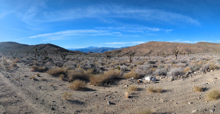
I figured the dunes were one of a handful of highlights to the greater route. But overall the route had a unique feel to it. First off, the Joshua Trees are such a different type of plant to see. At first there are a few scattered about, then you are in a forest of them. Climbing Cucamonga Canyon was a forest of pinyon, Joshua Trees, and either mesquite or mahogany. Next was the topography, you are riding in canyons a thousand feet deep, and then in Eureka Valley the mountains are 3-5,000’ above you. The dunes themselves rise 600’ from the valley floor.


Then there is the color and texture in the mountains which Death Valley is famous for. From my first visit to Death Valley I saw the Great Basin in one place with the right ballance of interpretive information at either the visitors center at Furnace Creek or at individual points of interest in the park. Everything that I love about touring the Basin and Range can be found in Death Valley NP. The challenges of desert touring are there but they are not unsurmountable with proper planning. Doug’s route Cottonwood Canyon – Death, Saline, and Eureka Valleys is well planned. There aren’t too many options for a backroads loop in the park so chances are if you try to come up with a route you will converge on this loop.

I like the options of cutting south off Cucomungo Canyon through Tule Canyon into Death Valley. I like the connection to Goldfield through Lida Valley. From the start or end I would like to include Horse Thief Canyon through the Piper Mountain Wilderness. Death Valley/Big Pine Road is a shortcut loop with significant elevation (20 miles, 2,600’) through the Last Chance Range and offers additional routes like the cherry stem road to Last Chance Spring. This is just to name a few options I was considering from my quick overnight.

By the numbers on Day 1 I rode 48 miles with about 2,800’ of climbing and since this is Death Valley where remarkable low elevation is king, I descended 5,100’ to a low point of 2,900’. While this is not supper low it is lower than the average low of 5,000’ of Nevada’s Great Basin. The start of the ride, Willow Creek would be a great place to camp prior to the ride to avoid the long day of driving to the start. For me my day started at 2:30 am. This is something I don’t mind when I am soloing a trip, but I don’t ask this of others. It is so hard to say what the highlights of day 1 were, it was all so novel.

Day 2 I rode 32 miles with about 2,900’ of climbing. As an out-and-back there is always the benefit of seeing things from a different angle and having a mindset with a different goal. With hindsight I could have returned via Horse Thief Canyon, for about the same investment, though the road looks much rougher than Eureka Valley Road.

What I carried It is so challenging to trust “warm” weather forecasts when bikepacking in the winter. But I scaled down a few items. I didn’t bring a down jacket or my Z-rest sleeping pad. I did bring, my synthetic quilt and my down quilt. My standard sleep items are my inflatable NeoAir, insulated top sheet and pillow from Klymt and sleeping bag liner from Sea-to-Summit. While this modular system makes sense, I feel like it gets a bit cumbersome breaking it down and building it back up every day in the tent. How did the night go? It was warm when I went to bed so I just had my 50o quilt over me. Around 3:30 am I woke cold. I felt cold between me and the ground and I hadn’t changed into my spare base layer that I bring to sleep in. But the easiest solution was to grab my second quilt, and now I was plenty warm. The ground was damp from past storms so I think that added to the cold feel.

I was using the new handlebar harness from Nuke Sunrise Bags, the updated and tested Strutfortress harness. I also had the Attache Pouch for my camera equipment. The harness performed flawlessly carrying my tent, sleeping pad, sheet, and liner, and Attache Pouch over rutted and washboard roads. It was secure on my unicrown rigid fork.

In my Silo feedbag I had Embark Salted Maple Energy. It was a great alternative snack that will have a place in my riding food pantry. I also enjoyed a Walking Tamale from Fillo’s and I had a batch of dates wrapped in bacon.

While riding in Death Valley can be intimidating I think with some planning a great bikepacking trip can be had. I feel like I have seen quite a few photos from Death Valley on social media lately so I know people are getting out there.

WordPress just let me know this is Bikepacking Northern Nevada’s official 10 year anniversary! What a milestone. Thanks for going on this journey with me.


where can this route be found? RWGPS?
https://ridewithgps.com/routes/45388854 all my rides/routes are public on Ride with GPS
thanks for this, I’m looking forward to riding some of your routes this year!
Let me know how it goes!